T2. Los Angeles-Long Beach-Anaheim, CA
T1. New York-Newark-Jersey City, NY-NJ-PA
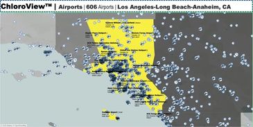
T2. Los Angeles-Long Beach-Anaheim, CA
606 airports
Extremely High airport density
--
1) Los Angeles International Airport (LAX) | Los Angeles, CA

T5. Dallas-Fort Worth-Arlington, TX
T1. New York-Newark-Jersey City, NY-NJ-PA
T2. Los Angeles-Long Beach-Anaheim, CA
504 airports
Very High airport density
--
1) Dallas Fort Worth International Airport (DFW) | Dallas-Fort Worth, TX
T7. Houston-The Woodlands-Sugar Land, TX
T1. New York-Newark-Jersey City, NY-NJ-PA
T1. New York-Newark-Jersey City, NY-NJ-PA
398 airports
Slightly High airport density
--
1) George Bush Intercontinental Houston Airport (IAH) | Houston, TX
T1. New York-Newark-Jersey City, NY-NJ-PA
T1. New York-Newark-Jersey City, NY-NJ-PA
T1. New York-Newark-Jersey City, NY-NJ-PA
379 airports
Slightly High airport density
--
1) Newark Liberty International Airport (EWR) | Newark, NJ
T15. Phoenix-Mesa-Scottsdale, AZ
T3. Chicago-Naperville-Elgin, IL-IN-WI
T3. Chicago-Naperville-Elgin, IL-IN-WI
361 airports
Slightly Low airport density
--
1) Phoenix Sky Harbor International Airport (PHX) | Phoenix, AZ
T3. Chicago-Naperville-Elgin, IL-IN-WI
T3. Chicago-Naperville-Elgin, IL-IN-WI
T3. Chicago-Naperville-Elgin, IL-IN-WI
302 airports
Moderate airport density
--
1) Chicago O'Hare International Airport (ORD) | Chicago, IL
T10. Atlanta-Sandy Springs-Roswell, GA
T3. Chicago-Naperville-Elgin, IL-IN-WI
T10. Atlanta-Sandy Springs-Roswell, GA
244 airports
Moderate airport density
--
1) Hartsfield Jackson Atlanta International Airport (ATL) | Atlanta, GA
T113. Anchorage, AK
T3. Chicago-Naperville-Elgin, IL-IN-WI
T10. Atlanta-Sandy Springs-Roswell, GA
236 airports
Very Low airport density
--
1) Ted Stevens Anchorage International Airport (ANC) | Anchorage, AK
T19. Riverside-San Bernardino-Ontario, CA
T9. Philadelphia-Camden-Wilmington, PA-NJ-DE-MD
229 airports
Extremely Low airport density
--
1) Ontario International Airport (ONT) | Ontario, CA
T9. Philadelphia-Camden-Wilmington, PA-NJ-DE-MD
T9. Philadelphia-Camden-Wilmington, PA-NJ-DE-MD
222 airports
High airport density
--
1) Philadelphia International Airport (PHL) | Philadelphia, PA
T35. San Antonio-New Braunfels, TX
177 airports
Slightly Low airport density
--
1) San Antonio International Airport (SAT) | San Antonio, TX
T14. Minneapolis-St. Paul-Bloomington, MN-WI
174 airports
Low airport density
--
1) Minneapolis Saint Paul International Airport (MSP) | Minneapolis, MN